Munro Hillwalk Ben More Assynt and Conival
Munro, Hillwalk, Ben, More, Assynt, Conival
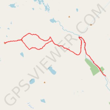
- Distance: 30.3 Km
- Elevation gain: 1,346 m
- Maximum elevation: 992 m
- Elevation loss: 1,347 m
- Minimum elevation: 110 m
- Moving time: 7 h 17 m
- Moving speed: 4.1 Km/h
- Maximum speed: 26.1 Km/h
- Total time: 8 h 34 m
- Global speed: 3.5 Km/h
Interactive trail map
Trail profile
- Distance: 30.3 Km
- Elevation gain: 1,346 m
- Maximum elevation: 992 m
- Elevation loss: 1,347 m
- Minimum elevation: 110 m
- Moving time: 7 h 17 m
- Moving speed: 4.1 Km/h
- Maximum speed: 26.1 Km/h
- Total time: 8 h 34 m
- Global speed: 3.5 Km/h
About this trail
Name: Munro Hillwalk Ben More Assynt and Conival trail, distance, elevation, map, profile, GPS track
Start: Highland, Scotland, United Kingdom (58.10987 -4.73573)
End: Highland, Scotland, United Kingdom (58.10986 -4.73576)
Coordinates: 58.10981 -4.88446 58.14322 -4.73565