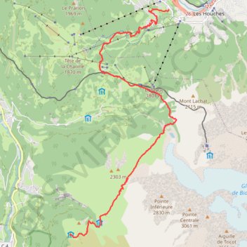
Day 01: Les Houches to Auberge du Truc
- Distance: 14.1 Km
- Elevation gain: 1,480 m
- Maximum elevation: 2,117 m
- Elevation loss: 777 m
- Minimum elevation: 1,022 m
- Moving time: 4 h 30 m
- Moving speed: 3.1 Km/h
- Maximum speed: 5.7 Km/h
- Total time: 8 h 5 m
- Global speed: 1.7 Km/h
Interactive trail map
Trail profile
- Distance: 14.1 Km
- Elevation gain: 1,480 m
- Maximum elevation: 2,117 m
- Elevation loss: 777 m
- Minimum elevation: 1,022 m
- Moving time: 4 h 30 m
- Moving speed: 3.1 Km/h
- Maximum speed: 5.7 Km/h
- Total time: 8 h 5 m
- Global speed: 1.7 Km/h
About this trail
Name: Day 01: Les Houches to Auberge du Truc trail, distance, elevation, map, profile, GPS track
Coordinates: 45.83546 6.74938 45.89259 6.78754
Other hiking, mountain biking, running and outdoor activity trails
Click on a trail to view its statistics, map and profile.
Ultra-Trail du Mont Blanc (UTMB)
France > Auvergne-Rhône-Alpes > Upper Savoy > Chamonix-Mont-Blanc
Distance: 167.8 Km • Elevation gain: 10,450 m • Maximum elevation: 2,535 m
UTMB 2020
France > Auvergne-Rhône-Alpes > Upper Savoy > Chamonix-Mont-Blanc > Les Bossons
Total: 171.3km
Distance: 168.1 Km • Elevation gain: 10,526 m • Maximum elevation: 2,574 m
TTdMB-1 Tour Du Mont Blanc - Itinéraire Principal
France > Auvergne-Rhône-Alpes > Upper Savoy > Chamonix-Mont-Blanc
Distance: 166.0 Km • Elevation gain: 10,535 m • Maximum elevation: 2,537 m
PT23DS2 Lörrach → Cadaqués
Germany > Baden-Württemberg > Landkreis Lörrach > Lörrach (Kernstadt)
Distance: 1,050.7 Km • Elevation gain: 13,130 m • Maximum elevation: 1,505 m