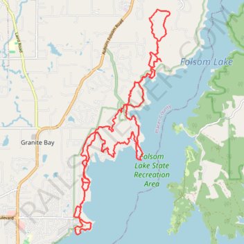
Long trail run in Folsom Lake State Recreation Area
- Distance: 28.5 Km
- Elevation gain: 463 m
- Maximum elevation: 225 m
- Elevation loss: 467 m
- Minimum elevation: 138 m
- Moving time: 4 h 23 m
- Moving speed: 6.5 Km/h
- Maximum speed: 18.5 Km/h
- Total time: 4 h 35 m
- Global speed: 6.2 Km/h
Interactive trail map
Trail profile
- Distance: 28.5 Km
- Elevation gain: 463 m
- Maximum elevation: 225 m
- Elevation loss: 467 m
- Minimum elevation: 138 m
- Moving time: 4 h 23 m
- Moving speed: 6.5 Km/h
- Maximum speed: 18.5 Km/h
- Total time: 4 h 35 m
- Global speed: 6.2 Km/h
About this trail
Name: Long trail run in Folsom Lake State Recreation Area trail, distance, elevation, map, profile, GPS track
Start: Park Road, Granite Bay, Placer County, California, United States (38.75055 -121.14780)
End: Park Road, Granite Bay, Placer County, California, United States (38.74761 -121.14839)
Coordinates: 38.73899 -121.15154 38.79812 -121.11920