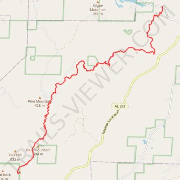
Pinhoti Trail between County Road 24 Trailhead and Blue Mountain Shelter
- Distance: 16.9 Km
- Elevation gain: 650 m
- Maximum elevation: 601 m
- Elevation loss: 329 m
- Minimum elevation: 230 m
- Moving time: 4 h 38 m
- Moving speed: 3.6 Km/h
- Maximum speed: 5.3 Km/h
- Total time: 6 h 32 m
- Global speed: 2.6 Km/h
Interactive trail map
Trail profile
- Distance: 16.9 Km
- Elevation gain: 650 m
- Maximum elevation: 601 m
- Elevation loss: 329 m
- Minimum elevation: 230 m
- Moving time: 4 h 38 m
- Moving speed: 3.6 Km/h
- Maximum speed: 5.3 Km/h
- Total time: 6 h 32 m
- Global speed: 2.6 Km/h
About this trail
Name: Pinhoti Trail between County Road 24 Trailhead and Blue Mountain Shelter trail, distance, elevation, map, profile, GPS track
End: Blue Mountain Shelter, Pinhoti Trail, Cleburne County, Alabama, United States (33.49464 -85.79954)
Coordinates: 33.49442 -85.80104 33.56185 -85.73061