Import a GPX file

Samuel A. Tamposi Water Supply Reserve Loop Hike

  • Distance: 8.4 Km
  • Elevation gain: 69 m
  • Maximum elevation: 96 m
  • Elevation loss: 69 m
  • Minimum elevation: 55 m
  • Moving time: 1 h 8 m
  • Moving speed: 7.3 Km/h
  • Maximum speed: 14.9 Km/h
  • Total time: 1 h 21 m
  • Global speed: 6.2 Km/h

Interactive trail map

Trail profile

  • Distance: 8.4 Km
  • Elevation gain: 69 m
  • Maximum elevation: 96 m
  • Elevation loss: 69 m
  • Minimum elevation: 55 m
  • Moving time: 1 h 8 m
  • Moving speed: 7.3 Km/h
  • Maximum speed: 14.9 Km/h
  • Total time: 1 h 21 m
  • Global speed: 6.2 Km/h

About this trail
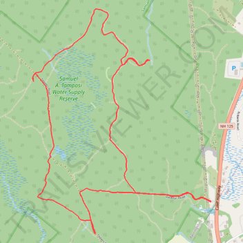
Name: Samuel A. Tamposi Water Supply Reserve Loop Hike trail, distance, elevation, map, profile, GPS track

Start: Rabbitat Road, Barrington, Strafford County, New Hampshire, 30825, United States (43.16272 -71.00667)

End: Rabbitat Road, Barrington, Strafford County, New Hampshire, 30825, United States (43.16280 -71.00667)

Coordinates: 43.16002 -71.02734 43.17903 -71.00667

Gear up for your next adventure:

🧼Clip-on Hand Sanitizer - Maintain hygiene when water for washing is scarce
🪑Portable Backpacking Chairs - A comfortable seat for studying maps at the end of the day
🔭Compact Hiking Binoculars - Lightweight optics for scouting routes or birdwatching
👣Snake & Scrub Gaiters - Protection against spinifex, mud, and snakes while walking off-track
🧥Down Jackets - Insulated jackets for cold weather

As an Amazon Associate, this site earns from qualifying purchases at no extra cost to you.