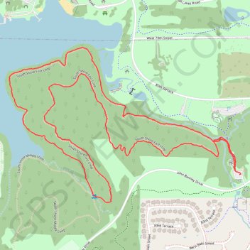
South Shore East Loop in Shawnee Mission Park
The South Shore East Loop is a delightful trail that offers a serene hiking experience surrounded by lush trees and scenic views of the lake. As you traverse the loop, you can expect to encounter a variety of wildlife and picturesque landscapes, making it an excellent choice for nature lovers and those seeking a peaceful outdoor escape. #Hiking #Loop #Lake #Forest #Nature
- Distance: 5.1 Km
- Elevation gain: 61 m
- Maximum elevation: 296 m
- Elevation loss: 60 m
- Minimum elevation: 268 m
- Moving time: 1 h 27 m
- Moving speed: 3.5 Km/h
- Maximum speed: 5.4 Km/h
- Total time: 1 h 32 m
- Global speed: 3.3 Km/h
Interactive trail map
Trail profile
- Distance: 5.1 Km
- Elevation gain: 61 m
- Maximum elevation: 296 m
- Elevation loss: 60 m
- Minimum elevation: 268 m
- Moving time: 1 h 27 m
- Moving speed: 3.5 Km/h
- Maximum speed: 5.4 Km/h
- Total time: 1 h 32 m
- Global speed: 3.3 Km/h
About this trail
Name: South Shore East Loop in Shawnee Mission Park trail, distance, elevation, map, profile, GPS track
Coordinates: 38.97798 -94.80114 38.98499 -94.78770