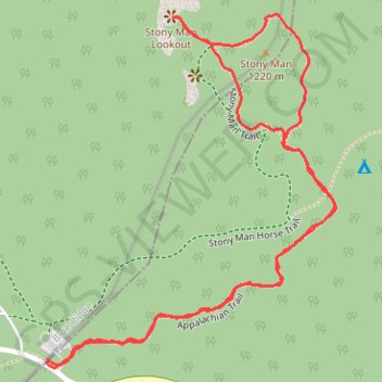
Stony Man Trail in Shenandoah National Park
The Stony Man Trail offers a delightful and easy hike that leads to breathtaking panoramic views. As you ascend through a lush forest, you'll reach the rocky outcrop at the summit, where you can gaze out over the sprawling Shenandoah Valley and spot nearby landmarks like Luray and Mary's Rock, all while enjoying the invigorating mountain breeze. #Hiking #Mountain #Forest #Nature
- Distance: 2.6 Km
- Elevation gain: 100 m
- Maximum elevation: 1,213 m
- Elevation loss: 100 m
- Minimum elevation: 1,126 m
- Moving time: 37 m 40 s
- Moving speed: 4.1 Km/h
- Maximum speed: 9.0 Km/h
- Total time: 46 m 36 s
- Global speed: 3.3 Km/h
Interactive trail map
Trail profile
- Distance: 2.6 Km
- Elevation gain: 100 m
- Maximum elevation: 1,213 m
- Elevation loss: 100 m
- Minimum elevation: 1,126 m
- Moving time: 37 m 40 s
- Moving speed: 4.1 Km/h
- Maximum speed: 9.0 Km/h
- Total time: 46 m 36 s
- Global speed: 3.3 Km/h
About this trail
Name: Stony Man Trail in Shenandoah National Park trail, distance, elevation, map, profile, GPS track
Start: Appalachian Trail, Skyland, Madison County, Virginia, United States (38.59291 -78.37619)
End: Appalachian Trail, Skyland, Madison County, Virginia, United States (38.59288 -78.37621)
Coordinates: 38.59279 -78.37621 38.59850 -78.37022
Other hiking, mountain biking, running and outdoor activity trails
Click on a trail to view its statistics, map and profile.
Stony Man Loop Trail via Appalachian Trail in Shenandoah National Park
United States > Virginia > Madison County
The Stony Man Loop Trail, accessible via the Appalachian Trail in Shenandoah National Park, offers hikers a rewarding experience with panoramic vistas. Along the route, one can observe the Blue Ridge Mountains, the expansive Shenandoah Valley stretching below, the Skyland Resort nestled amidst the landscape,…
Distance: 2.4 Km • Elevation gain: 100 m • Maximum elevation: 1,213 m