
Standing Bear Lake Loop Trail in Omaha
The Standing Bear Lake Loop Trail offers a pleasant, easy-going hike around the tranquil lake, making it a popular spot for walkers, joggers, and cyclists alike. The path meanders through open spaces and light woodlands, with scenic views of the lake, wildlife, and occasional fishermen along the shoreline. Its generally flat terrain and the added feature of a floating bridge enhance the experience, making it suitable for a relaxed, leisurely outing without being too strenuous. #Hiking #Loop #Lake #Dam #Forest #Nature
- Distance: 5.2 Km
- Elevation gain: 45 m
- Maximum elevation: 353 m
- Elevation loss: 44 m
- Minimum elevation: 334 m
- Moving time: 1 h 4 m
- Moving speed: 4.9 Km/h
- Maximum speed: 6.1 Km/h
- Total time: 1 h 5 m
- Global speed: 4.8 Km/h
Interactive trail map
Trail profile
- Distance: 5.2 Km
- Elevation gain: 45 m
- Maximum elevation: 353 m
- Elevation loss: 44 m
- Minimum elevation: 334 m
- Moving time: 1 h 4 m
- Moving speed: 4.9 Km/h
- Maximum speed: 6.1 Km/h
- Total time: 1 h 5 m
- Global speed: 4.8 Km/h
About this trail
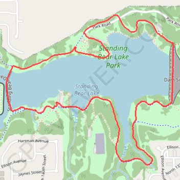
Name: Standing Bear Lake Loop Trail in Omaha trail, distance, elevation, map, profile, GPS track
Start: Standing Bear Lake Trail, Omaha, Douglas County, Nebraska, 68007, United States (41.31284 -96.13222)
End: Standing Bear Lake Trail, Omaha, Douglas County, Nebraska, 68007, United States (41.31283 -96.13213)
Coordinates: 41.30863 -96.13666 41.31867 -96.12176