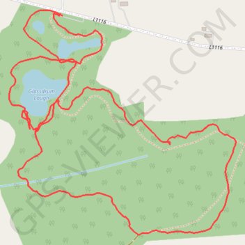
Green field park
- Distance: 3.1 Km
- Elevation gain: 21 m
- Maximum elevation: 118 m
- Elevation loss: 21 m
- Minimum elevation: 104 m
- Moving time: 58 m 43 s
- Moving speed: 3.2 Km/h
- Maximum speed: 6.7 Km/h
- Total time: 1 h 1 m
- Global speed: 3.0 Km/h
Interactive trail map
Trail profile
- Distance: 3.1 Km
- Elevation gain: 21 m
- Maximum elevation: 118 m
- Elevation loss: 21 m
- Minimum elevation: 104 m
- Moving time: 58 m 43 s
- Moving speed: 3.2 Km/h
- Maximum speed: 6.7 Km/h
- Total time: 1 h 1 m
- Global speed: 3.0 Km/h
About this trail
Name: Green field park trail, distance, elevation, map, profile, GPS track
Coordinates: 52.56707 -8.15446 52.57234 -8.14571
Other hiking, mountain biking, running and outdoor activity trails
Click on a trail to view its statistics, map and profile.
Thurles - Cork
Ireland > County Tipperary > Thurles
#Bike
Distance: 129.7 Km • Elevation gain: 1,137 m • Maximum elevation: 237 m