Hillwalk Skiddaw
Hillwalk, Skiddaw
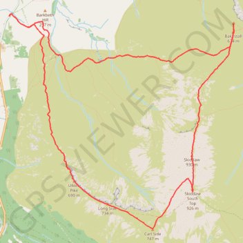
- Distance: 12.3 Km
- Elevation gain: 881 m
- Maximum elevation: 922 m
- Elevation loss: 881 m
- Minimum elevation: 153 m
- Moving time: 4 h 12 m
- Moving speed: 2.9 Km/h
- Maximum speed: 6.1 Km/h
- Total time: 4 h 33 m
- Global speed: 2.7 Km/h
Interactive trail map
Trail profile
- Distance: 12.3 Km
- Elevation gain: 881 m
- Maximum elevation: 922 m
- Elevation loss: 881 m
- Minimum elevation: 153 m
- Moving time: 4 h 12 m
- Moving speed: 2.9 Km/h
- Maximum speed: 6.1 Km/h
- Total time: 4 h 33 m
- Global speed: 2.7 Km/h
About this trail
Name: Hillwalk Skiddaw trail, distance, elevation, map, profile, GPS track
Start: High Side, Bassenthwaite, Cumberland, England, CA12 4QG, United Kingdom (54.66821 -3.18602)
End: High Side, Bassenthwaite, Cumberland, England, CA12 4QG, United Kingdom (54.66824 -3.18600)
Coordinates: 54.64236 -3.18608 54.66853 -3.13892
Other hiking, mountain biking, running and outdoor activity trails
Click on a trail to view its statistics, map and profile.
Blencathra, Knott and Skiddaw loop
United Kingdom > England > Cumberland > Keswick
Distance: 77.7 Km • Elevation gain: 4,362 m • Maximum elevation: 922 m