Thank you for supporting this site ❤️
Make a donation
Make a donation
Gear up for your next adventure:
As an Amazon Associate, this site earns from qualifying purchases at no extra cost to you.
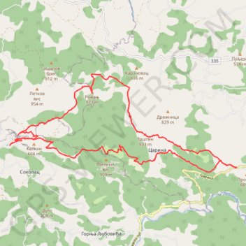
Sokolske planine
- Distance: 26.0 Km
- Elevation gain: 1,360 m
- Maximum elevation: 967 m
- Elevation loss: 1,358 m
- Minimum elevation: 379 m
- Moving time: 7 h 13 m
- Moving speed: 3.6 Km/h
- Maximum speed: 14.6 Km/h
- Total time: 9 h 17 m
- Global speed: 2.8 Km/h
Interactive trail map
Thank you for supporting this site ❤️
Make a donation
Make a donation
Gear up for your next adventure:
As an Amazon Associate, this site earns from qualifying purchases at no extra cost to you.
Trail profile
- Distance: 26.0 Km
- Elevation gain: 1,360 m
- Maximum elevation: 967 m
- Elevation loss: 1,358 m
- Minimum elevation: 379 m
- Moving time: 7 h 13 m
- Moving speed: 3.6 Km/h
- Maximum speed: 14.6 Km/h
- Total time: 9 h 17 m
- Global speed: 2.8 Km/h
Thank you for supporting this site ❤️
Make a donation
Make a donation
Gear up for your next adventure:
As an Amazon Associate, this site earns from qualifying purchases at no extra cost to you.
About this trail
Name: Sokolske planine trail, distance, elevation, map, profile, GPS track
Coordinates: 44.25961 19.42556 44.28735 19.51544
Thank you for supporting this site ❤️
Make a donation
Make a donation
Gear up for your next adventure:
As an Amazon Associate, this site earns from qualifying purchases at no extra cost to you.
Other hiking, mountain biking, running and outdoor activity trails
Click on a trail to view its statistics, map and profile.
2022_Yu
Slovenia > Ajdovščina > Žapuže
Distance: 2,457.3 Km • Elevation gain: 32,048 m • Maximum elevation: 1,950 m