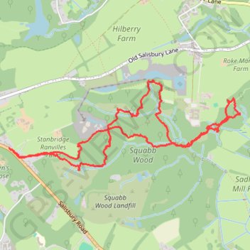
Squabb Wook
- Distance: 7.8 Km
- Elevation gain: 110 m
- Maximum elevation: 73 m
- Elevation loss: 109 m
- Minimum elevation: 30 m
- Moving time: 2 h 17 m
- Moving speed: 3.4 Km/h
- Maximum speed: 26.4 Km/h
- Total time: 2 h 58 m
- Global speed: 2.6 Km/h
Interactive trail map
Trail profile
- Distance: 7.8 Km
- Elevation gain: 110 m
- Maximum elevation: 73 m
- Elevation loss: 109 m
- Minimum elevation: 30 m
- Moving time: 2 h 17 m
- Moving speed: 3.4 Km/h
- Maximum speed: 26.4 Km/h
- Total time: 2 h 58 m
- Global speed: 2.6 Km/h
About this trail
Name: Squabb Wook trail, distance, elevation, map, profile, GPS track
Coordinates: 50.99441 -1.54414 51.00181 -1.51420
Other hiking, mountain biking, running and outdoor activity trails
Click on a trail to view its statistics, map and profile.
Romsey - Mottisfont & Dunbridge
United Kingdom > England > Hampshire > Test Valley > Romsey
Distance: 8.8 Km • Elevation gain: 52 m • Maximum elevation: 47 m