Thank you for supporting this site ❤️
Make a donation
Make a donation
Gear up for your next adventure:
As an Amazon Associate, this site earns from qualifying purchases at no extra cost to you.
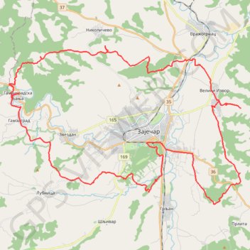
Track 001
- Distance: 67.0 Km
- Elevation gain: 1,495 m
- Maximum elevation: 433 m
- Elevation loss: 1,494 m
- Minimum elevation: 116 m
- Moving time: 14 h 13 m
- Moving speed: 4.7 Km/h
- Maximum speed: 63.8 Km/h
- Total time: 6 d 5 h
- Global speed: 0.4 Km/h
Interactive trail map
Thank you for supporting this site ❤️
Make a donation
Make a donation
Gear up for your next adventure:
As an Amazon Associate, this site earns from qualifying purchases at no extra cost to you.
Trail profile
- Distance: 67.0 Km
- Elevation gain: 1,495 m
- Maximum elevation: 433 m
- Elevation loss: 1,494 m
- Minimum elevation: 116 m
- Moving time: 14 h 13 m
- Moving speed: 4.7 Km/h
- Maximum speed: 63.8 Km/h
- Total time: 6 d 5 h
- Global speed: 0.4 Km/h
Thank you for supporting this site ❤️
Make a donation
Make a donation
Gear up for your next adventure:
As an Amazon Associate, this site earns from qualifying purchases at no extra cost to you.
About this trail
Name: Track 001 trail, distance, elevation, map, profile, GPS track
Coordinates: 43.86040 22.16707 43.95215 22.35271
Thank you for supporting this site ❤️
Make a donation
Make a donation
Gear up for your next adventure:
As an Amazon Associate, this site earns from qualifying purchases at no extra cost to you.