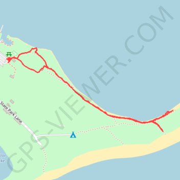
St. Andrews State Park
- Distance: 2.1 Km
- Elevation gain: 12 m
- Maximum elevation: 9 m
- Elevation loss: 12 m
- Minimum elevation: 0 m
- Moving time: 40 m 56 s
- Moving speed: 3.1 Km/h
- Maximum speed: 14.9 Km/h
- Total time: 43 m 36 s
- Global speed: 2.9 Km/h
Interactive trail map
Trail profile
- Distance: 2.1 Km
- Elevation gain: 12 m
- Maximum elevation: 9 m
- Elevation loss: 12 m
- Minimum elevation: 0 m
- Moving time: 40 m 56 s
- Moving speed: 3.1 Km/h
- Maximum speed: 14.9 Km/h
- Total time: 43 m 36 s
- Global speed: 2.9 Km/h
About this trail
Name: St. Andrews State Park trail, distance, elevation, map, profile, GPS track
Start: Campers Drive, Bay County, Florida, 32411, United States (30.13199 -85.73105)
End: Campers Drive, Bay County, Florida, 32411, United States (30.13189 -85.73095)
Coordinates: 30.12896 -85.73105 30.13245 -85.72303