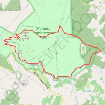
Import a GPX file

Morialta Loop

Morialta Conservation Park. #Hiking #Loop #Morialta

  • Distance: 9.4 Km
  • Elevation gain: 447 m
  • Maximum elevation: 493 m
  • Elevation loss: 446 m
  • Minimum elevation: 185 m
  • Moving time: 2 h 4 m
  • Moving speed: 4.6 Km/h
  • Maximum speed: 6.9 Km/h
  • Total time: 2 h 7 m
  • Global speed: 4.5 Km/h

Interactive trail map

Trail profile

  • Distance: 9.4 Km
  • Elevation gain: 447 m
  • Maximum elevation: 493 m
  • Elevation loss: 446 m
  • Minimum elevation: 185 m
  • Moving time: 2 h 4 m
  • Moving speed: 4.6 Km/h
  • Maximum speed: 6.9 Km/h
  • Total time: 2 h 7 m
  • Global speed: 4.5 Km/h

About this trail

Other hiking, mountain biking, running and outdoor activity trails

Click on a trail to view its statistics, map and profile.

Morialta Loop

Australia > South Australia

Morialta Conservation Park. #Hiking #Loop #Morialta

Distance: 8.1 Km • Elevation gain: 475 m • Maximum elevation: 356 m

Gear up for your next adventure:

🐍Snake Gaiters - Protection against snake bites
🎒3L Hydration Reservoirs - Hands-free drinking to stay hydrated on steep contour climbs
🔑Heavy Duty Carabiners - Secure gear to the outside of your pack for easy access
🌿Flora and Fauna Field Guides - Identify the plants and animals you encounter on your route
🔦Headlamps - Hands-free lighting for hiking

As an Amazon Associate, this site earns from qualifying purchases at no extra cost to you.