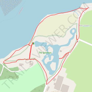
The Spinneys
- Distance: 1.7 Km
- Elevation gain: 8 m
- Maximum elevation: 8 m
- Elevation loss: 8 m
- Minimum elevation: 0 m
- Moving time: 41 m 2 s
- Moving speed: 2.4 Km/h
- Maximum speed: 4.9 Km/h
- Total time: 1 h 10 m
- Global speed: 1.4 Km/h
Interactive trail map
Trail profile
- Distance: 1.7 Km
- Elevation gain: 8 m
- Maximum elevation: 8 m
- Elevation loss: 8 m
- Minimum elevation: 0 m
- Moving time: 41 m 2 s
- Moving speed: 2.4 Km/h
- Maximum speed: 4.9 Km/h
- Total time: 1 h 10 m
- Global speed: 1.4 Km/h
About this trail
Name: The Spinneys trail, distance, elevation, map, profile, GPS track
Start: Aber-Ogwen, Llanllechid, Tal-y-bont, Gwynedd, Wales, LL57 3YH, United Kingdom (53.23046 -4.07611)
End: Aber-Ogwen, Llanllechid, Tal-y-bont, Gwynedd, Wales, LL57 3YH, United Kingdom (53.23046 -4.07609)
Coordinates: 53.22713 -4.08223 53.23046 -4.07609