Thank you for supporting this site ❤️
Make a donation
Make a donation
Gear up for your next adventure:
As an Amazon Associate, this site earns from qualifying purchases at no extra cost to you.
Monda Track
Interactive trail map
Thank you for supporting this site ❤️
Make a donation
Make a donation
Gear up for your next adventure:
As an Amazon Associate, this site earns from qualifying purchases at no extra cost to you.
Trail profile
- Distance: 17.4 Km
- Elevation gain: 754 m
- Maximum elevation: 942 m
- Elevation loss: 751 m
- Minimum elevation: 365 m
Thank you for supporting this site ❤️
Make a donation
Make a donation
Gear up for your next adventure:
As an Amazon Associate, this site earns from qualifying purchases at no extra cost to you.
About this trail
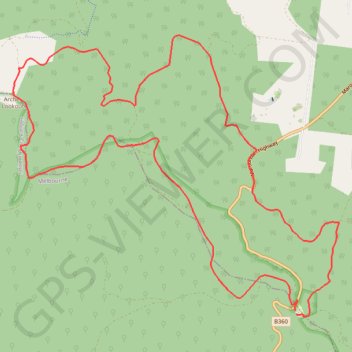
Name: Monda Track trail, distance, elevation, map, profile, GPS track
Coordinates: -37.59234 145.60034 -37.55923 145.64871
Topography: Melbourne topographic map, elevation, terrain
Thank you for supporting this site ❤️
Make a donation
Make a donation
Gear up for your next adventure:
⌚Altimeter Barometer Watches - Outdoor watches with built-in sensors to track altitude changes and weather shifts
As an Amazon Associate, this site earns from qualifying purchases at no extra cost to you.
Other hiking, mountain biking, running and outdoor activity trails
Click on a trail to view its statistics, map and profile.
Tallarook - Eildon - Hurstbridge
Australia > Victoria > Tallarook
#Bike
Distance: 278.8 Km • Elevation gain: 4,897 m • Maximum elevation: 868 m