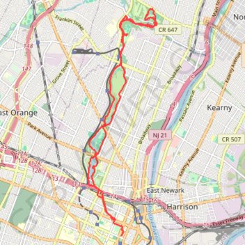
Branch Brook Park to Belleville Park Loop
Loop hike from Branch Brook Park to Belleville Park via Branch Brook Lake, Branch Brook Park Drive, Clarck's Pond, Mill Street, Second River and West Park Drive. #Hiking #Loop #Park #Lake #River #Nature #Forest
- Distance: 15.5 Km
- Elevation gain: 127 m
- Maximum elevation: 47 m
- Elevation loss: 138 m
- Minimum elevation: 15 m
- Moving time: 1 h 5 m
- Moving speed: 14.3 Km/h
- Maximum speed: 37.3 Km/h
- Total time: 1 h 18 m
- Global speed: 11.8 Km/h
Interactive trail map
Trail profile
- Distance: 15.5 Km
- Elevation gain: 127 m
- Maximum elevation: 47 m
- Elevation loss: 138 m
- Minimum elevation: 15 m
- Moving time: 1 h 5 m
- Moving speed: 14.3 Km/h
- Maximum speed: 37.3 Km/h
- Total time: 1 h 18 m
- Global speed: 11.8 Km/h
About this trail
Name: Branch Brook Park to Belleville Park Loop trail, distance, elevation, map, profile, GPS track
Coordinates: 40.73997 -74.18367 40.79003 -74.16370
Other hiking, mountain biking, running and outdoor activity trails
Click on a trail to view its statistics, map and profile.
Branch Brook Park Loop
United States > New Jersey > Essex County > Newark
Afternoon Ride
Distance: 17.8 Km • Elevation gain: 155 m • Maximum elevation: 48 m
Newark - Belleville
United States > New Jersey > Essex County > Newark > Roseville
Evening Ride
Distance: 18.1 Km • Elevation gain: 165 m • Maximum elevation: 48 m
Ironbound playground
United States > New Jersey > Essex County > Newark
Distance: 8.0 Km • Elevation gain: 66 m • Maximum elevation: 23 m
Ironbound, Harrison
United States > New Jersey > Essex County > Newark
Distance: 14.1 Km • Elevation gain: 128 m • Maximum elevation: 34 m
Cherry blossom
United States > New Jersey > Essex County > Newark
Evening Ride
Distance: 19.5 Km • Elevation gain: 163 m • Maximum elevation: 45 m
Afternoon Ride
United States > New Jersey > Essex County > Newark
Distance: 20.9 Km • Elevation gain: 198 m • Maximum elevation: 54 m
Cedar Grove
United States > New Jersey > Essex County > Newark
Afternoon Ride
Distance: 43.1 Km • Elevation gain: 399 m • Maximum elevation: 163 m