The Golden Cathedral
Hike to The Golden Cathedral via Golden Cathedral Trail and Escalante River in the Glen Canyon National Recreation Area. #Hiking #Nature #Canyon #Desert #Rock #River #Forest
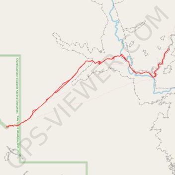
- Distance: 14.9 Km
- Elevation gain: 501 m
- Maximum elevation: 1,719 m
- Elevation loss: 501 m
- Minimum elevation: 1,389 m
- Moving time: 2 h 1 m
- Moving speed: 7.4 Km/h
- Maximum speed: 35.9 Km/h
- Total time: 2 h 1 m
- Global speed: 7.4 Km/h
Interactive trail map
Trail profile
- Distance: 14.9 Km
- Elevation gain: 501 m
- Maximum elevation: 1,719 m
- Elevation loss: 501 m
- Minimum elevation: 1,389 m
- Moving time: 2 h 1 m
- Moving speed: 7.4 Km/h
- Maximum speed: 35.9 Km/h
- Total time: 2 h 1 m
- Global speed: 7.4 Km/h
About this trail
Name: The Golden Cathedral trail, distance, elevation, map, profile, GPS track
End: Golden Cathedral Trailhead, Egypt Road, Garfield County, Utah, United States (37.59338 -111.21833)
Coordinates: 37.59319 -111.21834 37.61469 -111.16299
Other hiking, mountain biking, running and outdoor activity trails
Click on a trail to view its statistics, map and profile.
The Golden Cathedral via Golden Cathedral Trail in Glen Canyon National Recreation Area
United States > Utah > Garfield County
The Golden Cathedral Trail in Glen Canyon National Recreation Area offers a unique adventure with sweeping views of Neon Canyon’s surreal landscape. The route takes you through sections of deep sand and slick rock, often requiring off-trail navigation and careful route-finding. Along the way, you’ll cross…
Distance: 7.5 Km • Elevation gain: 143 m • Maximum elevation: 1,718 m