Make a donation
Gear up for your next adventure:
As an Amazon Associate, this site earns from qualifying purchases at no extra cost to you.
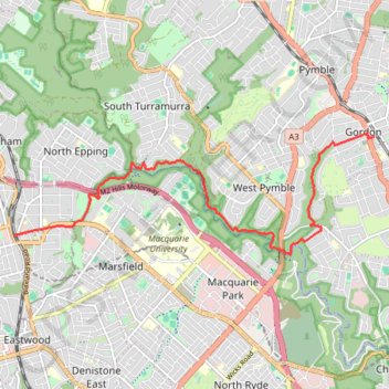
Epping - Gordon
Interactive trail map
Make a donation
Gear up for your next adventure:
As an Amazon Associate, this site earns from qualifying purchases at no extra cost to you.
Trail profile
- Distance: 11.6 Km
- Elevation gain: 267 m
- Maximum elevation: 129 m
- Elevation loss: 240 m
- Minimum elevation: 12 m
Make a donation
Gear up for your next adventure:
As an Amazon Associate, this site earns from qualifying purchases at no extra cost to you.
About this trail
Name: Epping - Gordon trail, distance, elevation, map, profile, GPS track
Coordinates: -33.77597 151.08192 -33.75568 151.15394
Topography: Sydney topographic map, elevation, terrain
Make a donation
Gear up for your next adventure:
As an Amazon Associate, this site earns from qualifying purchases at no extra cost to you.
Other hiking, mountain biking, running and outdoor activity trails
Click on a trail to view its statistics, map and profile.
Turramurra - Macquarie University
Australia > New South Wales > Sydney
Distance: 7.7 Km • Elevation gain: 104 m • Maximum elevation: 172 m
Hike through Lane Cove National Park along the Great North Walk
Australia > New South Wales > Sydney
Distance: 14.0 Km • Elevation gain: 336 m • Maximum elevation: 170 m
Make a donation
Gear up for your next adventure:
As an Amazon Associate, this site earns from qualifying purchases at no extra cost to you.