Waterfall - Heathcote
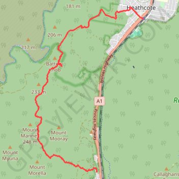
Interactive trail map
Trail profile
- Distance: 10.8 Km
- Elevation gain: 303 m
- Maximum elevation: 224 m
- Elevation loss: 328 m
- Minimum elevation: 68 m
About this trail
Name: Waterfall - Heathcote trail, distance, elevation, map, profile, GPS track
Coordinates: -34.13141 150.97132 -34.08458 151.00824
Topography: Sydney topographic map, elevation, terrain
Other hiking, mountain biking, running and outdoor activity trails
Click on a trail to view its statistics, map and profile.
Royal National Park Loop Ride between Heathcote and Waterfall
Australia > New South Wales > Sydney
Distance: 15.1 Km • Elevation gain: 224 m • Maximum elevation: 247 m
Royal National Park Ride between Waterfall and Heathcote
Australia > New South Wales > Sydney
Distance: 13.4 Km • Elevation gain: 156 m • Maximum elevation: 236 m
Heathcote - Miara - Depression Cave - Scouters
Australia > New South Wales > Sydney
Distance: 12.6 Km • Elevation gain: 431 m • Maximum elevation: 195 m
Waterfall Trail Run - Heathcote National Park
Australia > New South Wales > Sydney
Distance: 20.1 Km • Elevation gain: 521 m • Maximum elevation: 233 m