Thank you for supporting this site ❤️
Make a donation
Make a donation
Gear up for your next adventure:
As an Amazon Associate, this site earns from qualifying purchases at no extra cost to you.
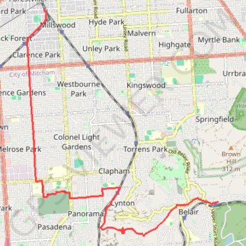
Belair National Park - Goodwood
#Bike
- Distance: 12.6 Km
- Elevation gain: 36 m
- Maximum elevation: 324 m
- Elevation loss: 308 m
- Minimum elevation: 36 m
Interactive trail map
Thank you for supporting this site ❤️
Make a donation
Make a donation
Gear up for your next adventure:
As an Amazon Associate, this site earns from qualifying purchases at no extra cost to you.
Trail profile
- Distance: 12.6 Km
- Elevation gain: 36 m
- Maximum elevation: 324 m
- Elevation loss: 308 m
- Minimum elevation: 36 m
Thank you for supporting this site ❤️
Make a donation
Make a donation
Gear up for your next adventure:
As an Amazon Associate, this site earns from qualifying purchases at no extra cost to you.
About this trail
Name: Belair National Park - Goodwood trail, distance, elevation, map, profile, GPS track
Coordinates: -35.00497 138.58126 -34.95373 138.63384
Topography: Adelaide topographic map, elevation, terrain
Thank you for supporting this site ❤️
Make a donation
Make a donation
Gear up for your next adventure:
As an Amazon Associate, this site earns from qualifying purchases at no extra cost to you.
Other hiking, mountain biking, running and outdoor activity trails
Click on a trail to view its statistics, map and profile.
Brighton - Adelaide
Australia > South Australia > Adelaide
#Bike
Distance: 23.4 Km • Elevation gain: 101 m • Maximum elevation: 53 m