Import a GPX file

Holly State Recreation Area

Loop hike in the Holly State Recreation Area. #Hiking #Loop #Nature #Forest

  • Distance: 3.7 Km
  • Elevation gain: 36 m
  • Maximum elevation: 334 m
  • Elevation loss: 35 m
  • Minimum elevation: 320 m
  • Moving time: 1 h 18 m
  • Moving speed: 2.9 Km/h
  • Maximum speed: 5.4 Km/h
  • Total time: 1 h 20 m
  • Global speed: 2.8 Km/h

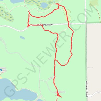
Interactive trail map

Trail profile

  • Distance: 3.7 Km
  • Elevation gain: 36 m
  • Maximum elevation: 334 m
  • Elevation loss: 35 m
  • Minimum elevation: 320 m
  • Moving time: 1 h 18 m
  • Moving speed: 2.9 Km/h
  • Maximum speed: 5.4 Km/h
  • Total time: 1 h 20 m
  • Global speed: 2.8 Km/h

About this trail

Name: Holly State Recreation Area trail, distance, elevation, map, profile, GPS track

Start: Wildwood Road, Austin Corners, Oakland County, Michigan, 48442, United States (42.80999 -83.51519)

End: Wildwood Road, Austin Corners, Oakland County, Michigan, 48442, United States (42.80886 -83.51453)

Coordinates: 42.80830 -83.51929 42.81914 -83.51207

Gear up for your next adventure:

🎒3L Hydration Reservoirs - Hands-free drinking to stay hydrated on steep contour climbs
🔋Solar Power Banks - Solar chargers for outdoors
👄SPF Lip Balm - Prevent sun and wind-burnt lips on mountain ridges
☀️Portable Solar Chargers - High-efficiency panels to hang on your backpack while walking
📱Shockproof Phone Cases - Extra protection for your smartphone against drops on rocky terrain

As an Amazon Associate, this site earns from qualifying purchases at no extra cost to you.