Make a donation
Gear up for your next adventure:
As an Amazon Associate, this site earns from qualifying purchases at no extra cost to you.
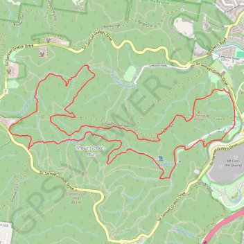
Mount Coot-tha
Loop hike / run from Bardon to Mount Coot-tha via The Pinnacle, Simpson Falls, Ithaca Creek and Bush Chapel. #Hiking #Running #Loop #Nature #Mountain #Forest #River #Falls
- Distance: 11.0 Km
- Elevation gain: 392 m
- Maximum elevation: 247 m
- Elevation loss: 391 m
- Minimum elevation: 70 m
- Moving time: 1 h 41 m
- Moving speed: 6.5 Km/h
- Maximum speed: 12.2 Km/h
- Total time: 1 h 42 m
- Global speed: 6.4 Km/h
Interactive trail map
Make a donation
Gear up for your next adventure:
As an Amazon Associate, this site earns from qualifying purchases at no extra cost to you.
Trail profile
- Distance: 11.0 Km
- Elevation gain: 392 m
- Maximum elevation: 247 m
- Elevation loss: 391 m
- Minimum elevation: 70 m
- Moving time: 1 h 41 m
- Moving speed: 6.5 Km/h
- Maximum speed: 12.2 Km/h
- Total time: 1 h 42 m
- Global speed: 6.4 Km/h
Make a donation
Gear up for your next adventure:
As an Amazon Associate, this site earns from qualifying purchases at no extra cost to you.
About this trail
Name: Mount Coot-tha trail, distance, elevation, map, profile, GPS track
Coordinates: -27.47791 152.94342 -27.46568 152.97082
Topography: Queensland topographic map, elevation, terrain
Make a donation
Gear up for your next adventure:
As an Amazon Associate, this site earns from qualifying purchases at no extra cost to you.
Other hiking, mountain biking, running and outdoor activity trails
Click on a trail to view its statistics, map and profile.
20260530072618 Hiking·Zepp Coach
Australia > Queensland > Brisbane
Distance: 3.1 Km • Elevation gain: 80 m • Maximum elevation: 150 m
Make a donation
Gear up for your next adventure:
As an Amazon Associate, this site earns from qualifying purchases at no extra cost to you.
Make a donation
Gear up for your next adventure:
As an Amazon Associate, this site earns from qualifying purchases at no extra cost to you.
Mount Coot-Tha trails
Brisbane Trail Run
Distance: 23.3 Km • Elevation gain: 842 m • Maximum elevation: 261 m
Bardon trails
Brisbane Trail Run
Distance: 13.3 Km • Elevation gain: 422 m • Maximum elevation: 171 m