Thank you for supporting this site ❤️
Make a donation
Make a donation
Gear up for your next adventure:
As an Amazon Associate, this site earns from qualifying purchases at no extra cost to you.
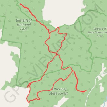
Butterleaf National Park and State Forest
- Distance: 28.8 Km
- Elevation gain: 719 m
- Maximum elevation: 1,309 m
- Elevation loss: 722 m
- Minimum elevation: 1,027 m
- Moving time: 2 h 50 m
- Moving speed: 10.1 Km/h
- Maximum speed: 18.1 Km/h
- Total time: 3 h 8 m
- Global speed: 9.2 Km/h
Interactive trail map
Thank you for supporting this site ❤️
Make a donation
Make a donation
Gear up for your next adventure:
As an Amazon Associate, this site earns from qualifying purchases at no extra cost to you.
Trail profile
- Distance: 28.8 Km
- Elevation gain: 719 m
- Maximum elevation: 1,309 m
- Elevation loss: 722 m
- Minimum elevation: 1,027 m
- Moving time: 2 h 50 m
- Moving speed: 10.1 Km/h
- Maximum speed: 18.1 Km/h
- Total time: 3 h 8 m
- Global speed: 9.2 Km/h
Thank you for supporting this site ❤️
Make a donation
Make a donation
Gear up for your next adventure:
As an Amazon Associate, this site earns from qualifying purchases at no extra cost to you.
About this trail
Name: Butterleaf National Park and State Forest trail, distance, elevation, map, profile, GPS track
Coordinates: -29.57070 152.01687 -29.50969 152.06415
Topography: New South Wales topographic map, elevation, terrain
Thank you for supporting this site ❤️
Make a donation
Make a donation
Gear up for your next adventure:
As an Amazon Associate, this site earns from qualifying purchases at no extra cost to you.