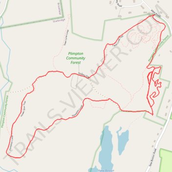
Loop walk at Plimpton Forest in Sturbridge
- Distance: 5.3 Km
- Elevation gain: 59 m
- Maximum elevation: 243 m
- Elevation loss: 59 m
- Minimum elevation: 192 m
- Moving time: 1 h 28 m
- Moving speed: 3.6 Km/h
- Maximum speed: 8.0 Km/h
- Total time: 1 h 36 m
- Global speed: 3.3 Km/h
Interactive trail map
Trail profile
- Distance: 5.3 Km
- Elevation gain: 59 m
- Maximum elevation: 243 m
- Elevation loss: 59 m
- Minimum elevation: 192 m
- Moving time: 1 h 28 m
- Moving speed: 3.6 Km/h
- Maximum speed: 8.0 Km/h
- Total time: 1 h 36 m
- Global speed: 3.3 Km/h
About this trail
Name: Loop walk at Plimpton Forest in Sturbridge trail, distance, elevation, map, profile, GPS track
Start: Holden Trail, Sturbridge, Worcester County, Massachusetts, 01566, United States (42.14823 -72.07897)
End: Holden Trail, Sturbridge, Worcester County, Massachusetts, 01566, United States (42.14813 -72.07904)
Coordinates: 42.14544 -72.09165 42.15462 -72.07792
Other hiking, mountain biking, running and outdoor activity trails
Click on a trail to view its statistics, map and profile.
Short walk on start of Holden Trail at Plimpton Forest in Sturbridge
United States > Massachusetts > Worcester County > Sturbridge
Distance: 1.2 Km • Elevation gain: 30 m • Maximum elevation: 214 m