
Watson Lake Loop
The Watson Lake Loop offers a scenic and diverse hiking experience with a variety of landscapes to enjoy. Hikers are treated to expansive views of Watson Lake, surrounded by unique rock formations known as the Granite Dells, and occasionally, a lush oasis near the Granite Creek Dam. The route features peaceful lakeside paths, rugged terrain with short, rocky ascents, and stretches through forests and wildflower fields, making it a satisfying journey for nature lovers. #Hiking #Lake #Nature #Loop #Rock
- Distance: 7.5 Km
- Elevation gain: 122 m
- Maximum elevation: 1,600 m
- Elevation loss: 124 m
- Minimum elevation: 1,554 m
- Moving time: 2 h 3 m
- Moving speed: 3.6 Km/h
- Maximum speed: 6.7 Km/h
- Total time: 2 h 22 m
- Global speed: 3.1 Km/h
Interactive trail map
Trail profile
- Distance: 7.5 Km
- Elevation gain: 122 m
- Maximum elevation: 1,600 m
- Elevation loss: 124 m
- Minimum elevation: 1,554 m
- Moving time: 2 h 3 m
- Moving speed: 3.6 Km/h
- Maximum speed: 6.7 Km/h
- Total time: 2 h 22 m
- Global speed: 3.1 Km/h
About this trail
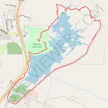
Name: Watson Lake Loop trail, distance, elevation, map, profile, GPS track
Start: Prescott, Yavapai County, Arizona, 86201, United States (34.59020 -112.42045)
End: Prescott, Yavapai County, Arizona, 86201, United States (34.59034 -112.42114)
Coordinates: 34.57872 -112.42853 34.59744 -112.40732