Thank you for supporting this site ❤️
Make a donation
Make a donation
Gear up for your next adventure:
As an Amazon Associate, this site earns from qualifying purchases at no extra cost to you.
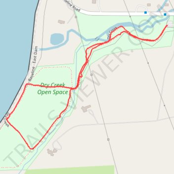
Dry Creek trail loop
- Distance: 2.3 Km
- Elevation gain: 14 m
- Maximum elevation: 1,619 m
- Elevation loss: 14 m
- Minimum elevation: 1,608 m
- Moving time: 26 m 10 s
- Moving speed: 5.3 Km/h
- Maximum speed: 18.3 Km/h
- Total time: 26 m 49 s
- Global speed: 5.2 Km/h
Interactive trail map
Thank you for supporting this site ❤️
Make a donation
Make a donation
Gear up for your next adventure:
As an Amazon Associate, this site earns from qualifying purchases at no extra cost to you.
Trail profile
- Distance: 2.3 Km
- Elevation gain: 14 m
- Maximum elevation: 1,619 m
- Elevation loss: 14 m
- Minimum elevation: 1,608 m
- Moving time: 26 m 10 s
- Moving speed: 5.3 Km/h
- Maximum speed: 18.3 Km/h
- Total time: 26 m 49 s
- Global speed: 5.2 Km/h
Thank you for supporting this site ❤️
Make a donation
Make a donation
Gear up for your next adventure:
As an Amazon Associate, this site earns from qualifying purchases at no extra cost to you.
About this trail
Name: Dry Creek trail loop trail, distance, elevation, map, profile, GPS track
Start: Dry Creek, Boulder County, Colorado, 80303, United States (39.99961 -105.19106)
End: Dry Creek, Boulder County, Colorado, 80303, United States (39.99957 -105.19113)
Coordinates: 39.99439 -105.19992 39.99961 -105.19106
Thank you for supporting this site ❤️
Make a donation
Make a donation
Gear up for your next adventure:
As an Amazon Associate, this site earns from qualifying purchases at no extra cost to you.