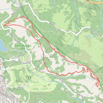
Big Springs Trail and Seaview Trail Loop in Tilden Regional Park
The Big Springs Trail and Seaview Trail Loop in Tilden Regional Park offers a delightful hiking experience, combining shaded woodlands with open meadows. Hikers can enjoy panoramic vistas of the San Francisco skyline, the bay, and the San Pablo Reservoir. The route's moderate elevation changes and diverse landscapes make it a rewarding choice for those seeking a balanced outdoor adventure. #Hiking #Loop #Forest #Nature #Overlook #Sea
- Distance: 6.9 Km
- Elevation gain: 295 m
- Maximum elevation: 506 m
- Elevation loss: 296 m
- Minimum elevation: 312 m
- Moving time: 1 h 24 m
- Moving speed: 4.9 Km/h
- Maximum speed: 7.9 Km/h
- Total time: 1 h 25 m
- Global speed: 4.8 Km/h
Interactive trail map
Trail profile
- Distance: 6.9 Km
- Elevation gain: 295 m
- Maximum elevation: 506 m
- Elevation loss: 296 m
- Minimum elevation: 312 m
- Moving time: 1 h 24 m
- Moving speed: 4.9 Km/h
- Maximum speed: 7.9 Km/h
- Total time: 1 h 25 m
- Global speed: 4.8 Km/h
About this trail
Name: Big Springs Trail and Seaview Trail Loop in Tilden Regional Park trail, distance, elevation, map, profile, GPS track
Start: Quarry Trail, Contra Costa County, California, 94708, United States (37.90046 -122.24959)
End: Quarry Trail, Contra Costa County, California, 94708, United States (37.90041 -122.24957)
Coordinates: 37.88745 -122.24959 37.90231 -122.22408
Other hiking, mountain biking, running and outdoor activity trails
Click on a trail to view its statistics, map and profile.
Meadows Canyon Trail - Wildcat Creek Trail
United States > California > Contra Costa County
Morning Run
Distance: 4.5 Km • Elevation gain: 177 m • Maximum elevation: 310 m