Thank you for supporting this site ❤️
Make a donation
Make a donation
Gear up for your next adventure:
⌚Altimeter Barometer Watches - Outdoor watches with built-in sensors to track altitude changes and weather shifts
As an Amazon Associate, this site earns from qualifying purchases at no extra cost to you.
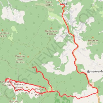
Trenutna trasa: 07 KOL 2018 11:37
- Distance: 23.1 Km
- Elevation gain: 784 m
- Maximum elevation: 1,612 m
- Elevation loss: 530 m
- Minimum elevation: 1,138 m
- Moving time: 3 h 53 m
- Moving speed: 5.9 Km/h
- Maximum speed: 57.0 Km/h
- Total time: 4 h 26 m
- Global speed: 5.2 Km/h
Interactive trail map
Thank you for supporting this site ❤️
Make a donation
Make a donation
Gear up for your next adventure:
🎒40L Day Hiking Backpacks - Comfortable packs with hydration support for long days exploring topographic peaks
As an Amazon Associate, this site earns from qualifying purchases at no extra cost to you.
Trail profile
- Distance: 23.1 Km
- Elevation gain: 784 m
- Maximum elevation: 1,612 m
- Elevation loss: 530 m
- Minimum elevation: 1,138 m
- Moving time: 3 h 53 m
- Moving speed: 5.9 Km/h
- Maximum speed: 57.0 Km/h
- Total time: 4 h 26 m
- Global speed: 5.2 Km/h
Thank you for supporting this site ❤️
Make a donation
Make a donation
Gear up for your next adventure:
As an Amazon Associate, this site earns from qualifying purchases at no extra cost to you.
About this trail
Name: Trenutna trasa: 07 KOL 2018 11:37 trail, distance, elevation, map, profile, GPS track
Coordinates: 43.40136 19.78140 43.44816 19.84408
Thank you for supporting this site ❤️
Make a donation
Make a donation
Gear up for your next adventure:
As an Amazon Associate, this site earns from qualifying purchases at no extra cost to you.
Other hiking, mountain biking, running and outdoor activity trails
Click on a trail to view its statistics, map and profile.
2022_Yu
Slovenia > Ajdovščina > Žapuže
Distance: 2,457.3 Km • Elevation gain: 32,048 m • Maximum elevation: 1,950 m