Mountbatten, Down Thomas
- Distance: 14.2 Km
- Elevation gain: 386 m
- Maximum elevation: 114 m
- Elevation loss: 381 m
- Minimum elevation: 0 m
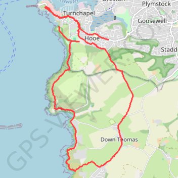
Interactive trail map
Trail profile
- Distance: 14.2 Km
- Elevation gain: 386 m
- Maximum elevation: 114 m
- Elevation loss: 381 m
- Minimum elevation: 0 m
About this trail
Name: Mountbatten, Down Thomas trail, distance, elevation, map, profile, GPS track
Start: Catslina Villas, Turnchapel, Plymouth, England, PL9 9XQ, United Kingdom (50.35505 -4.12425)
End: Hooe Road, Hooe, Plymouth, England, PL9 9NJ, United Kingdom (50.35223 -4.10736)
Coordinates: 50.32360 -4.12897 50.35936 -4.09908
Other hiking, mountain biking, running and outdoor activity trails
Click on a trail to view its statistics, map and profile.
Loop from Wembury in South Devon National Landscape
United Kingdom > England > Devon > South Hams > Wembury
Distance: 21.4 Km • Elevation gain: 640 m • Maximum elevation: 117 m
Plymouth eBike ride
United Kingdom > England > Plymouth
Distance: 43.3 Km • Elevation gain: 798 m • Maximum elevation: 116 m