
Franklin Mountains State Park - Aztec Cave Trail to Mundy's Gap, West Cottonwood, Agave Loop
Hiking
- Distance: 7.4 Km
- Elevation gain: 358 m
- Maximum elevation: 1,799 m
- Elevation loss: 374 m
- Minimum elevation: 1,480 m
- Moving time: 2 h 7 m
- Moving speed: 3.5 Km/h
- Maximum speed: 8.4 Km/h
- Total time: 2 h 37 m
- Global speed: 2.8 Km/h
Interactive trail map
Trail profile
- Distance: 7.4 Km
- Elevation gain: 358 m
- Maximum elevation: 1,799 m
- Elevation loss: 374 m
- Minimum elevation: 1,480 m
- Moving time: 2 h 7 m
- Moving speed: 3.5 Km/h
- Maximum speed: 8.4 Km/h
- Total time: 2 h 37 m
- Global speed: 2.8 Km/h
About this trail
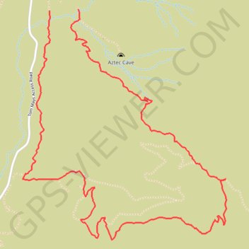
Name: Franklin Mountains State Park - Aztec Cave Trail to Mundy's Gap, West Cottonwood, Agave Loop trail, distance, elevation, map, profile, GPS track
Start: Aztec Caves Trail, El Paso, El Paso County, Texas, 79911, United States (31.92803 -106.50924)
End: Tom Mays Trail, El Paso, El Paso County, Texas, 79911, United States (31.92793 -106.51162)
Coordinates: 31.91198 -106.51380 31.92803 -106.49711