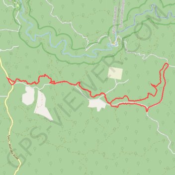
Bruntons Eaglehawk
- Distance: 23.6 Km
- Elevation gain: 352 m
- Maximum elevation: 413 m
- Elevation loss: 352 m
- Minimum elevation: 355 m
- Moving time: 1 h 10 m
- Moving speed: 20.0 Km/h
- Maximum speed: 65.9 Km/h
- Total time: 1 h 27 m
- Global speed: 16.2 Km/h
Interactive trail map
Trail profile
- Distance: 23.6 Km
- Elevation gain: 352 m
- Maximum elevation: 413 m
- Elevation loss: 352 m
- Minimum elevation: 355 m
- Moving time: 1 h 10 m
- Moving speed: 20.0 Km/h
- Maximum speed: 65.9 Km/h
- Total time: 1 h 27 m
- Global speed: 16.2 Km/h
About this trail
Name: Bruntons Eaglehawk trail, distance, elevation, map, profile, GPS track
Coordinates: -38.02624 146.41795 -38.00711 146.49931
Topography: Victoria topographic map, elevation, terrain
Other hiking, mountain biking, running and outdoor activity trails
Click on a trail to view its statistics, map and profile.
Traralgon - Walhalla - Woods Point
Australia > Victoria > Traralgon
#Bike
Distance: 124.6 Km • Elevation gain: 4,258 m • Maximum elevation: 1,165 m