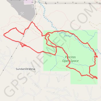
Placitas Open Space Loop
Loop hike / run / trail through Placitas Open Space. #Hiking #Running #Trail #Loop #Nature
- Distance: 11.1 Km
- Elevation gain: 188 m
- Maximum elevation: 1,714 m
- Elevation loss: 189 m
- Minimum elevation: 1,613 m
- Moving time: 1 h 17 m
- Moving speed: 8.5 Km/h
- Maximum speed: 37.8 Km/h
- Total time: 1 h 37 m
- Global speed: 6.8 Km/h
Interactive trail map
Trail profile
- Distance: 11.1 Km
- Elevation gain: 188 m
- Maximum elevation: 1,714 m
- Elevation loss: 189 m
- Minimum elevation: 1,613 m
- Moving time: 1 h 17 m
- Moving speed: 8.5 Km/h
- Maximum speed: 37.8 Km/h
- Total time: 1 h 37 m
- Global speed: 6.8 Km/h
About this trail
Name: Placitas Open Space Loop trail, distance, elevation, map, profile, GPS track
Coordinates: 35.32762 -106.49103 35.34277 -106.46038