Figure-8 Combination Loop (Bryce Canyon)
From Sunset Point, the route first follows the rim toward Sunrise Point, opening broad views over the Bryce Amphitheater before dropping into Queen’s Garden, where pale orange hoodoos, sculpted walls, and fir-dotted slopes gradually surround the trail. The descent leads from the overlook atmosphere of the rim into the intimate floor of the amphitheater, where the path threads between eroded fins and balanced formations before linking with the Tropic Trail area.
The hike then enters the more secluded and winding terrain of the Peekaboo Loop, a spectacular section of Bryce Canyon where the landscape becomes denser, rougher, and more theatrical. Along this part of the figure-eight route, the trail passes notable rock features such as Peek-a-Boo Arch, the Hindu Temples, and The Cathedral, with repeated changes in perspective revealing towers, windows, alcoves, and narrow gullies carved into the colorful limestone.
The return climbs back through the Navajo Loop, where the canyon walls close in again around switchbacks, pine trees, and famous formations. Passing Two Bridges and the iconic Thor’s Hammer, the route regains Sunset Point with a final sequence of close-up hoodoo views, making this loop one of Bryce Canyon’s most complete amphitheater hikes, blending rim panoramas, canyon-floor passages, and landmark rock formations in a single continuous circuit.
#Hiking #Loop #Canyon #Nature #Mountain #Rock #Forest #Park #Bryce
- Distance: 10.3 Km
- Elevation gain: 500 m
- Maximum elevation: 2,431 m
- Elevation loss: 500 m
- Minimum elevation: 2,260 m
- Moving time: 3 h 23 m
- Moving speed: 3.0 Km/h
- Maximum speed: 34.2 Km/h
- Total time: 4 h 11 m
- Global speed: 2.4 Km/h
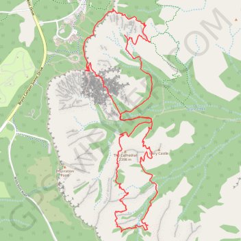
Interactive trail map
Trail profile
- Distance: 10.3 Km
- Elevation gain: 500 m
- Maximum elevation: 2,431 m
- Elevation loss: 500 m
- Minimum elevation: 2,260 m
- Moving time: 3 h 23 m
- Moving speed: 3.0 Km/h
- Maximum speed: 34.2 Km/h
- Total time: 4 h 11 m
- Global speed: 2.4 Km/h
About this trail
Name: Figure-8 Combination Loop (Bryce Canyon) trail, distance, elevation, map, profile, GPS track
Start: Navajo Loop Trail, Garfield County, Utah, United States (37.62272 -112.16610)
End: Navajo Loop Trail, Garfield County, Utah, United States (37.62266 -112.16608)
Coordinates: 37.60709 -112.16655 37.62841 -112.15760
Other hiking, mountain biking, running and outdoor activity trails
Click on a trail to view its statistics, map and profile.
Sunset Point and Sunrise Point via Rim Trail in Bryce Canyon National Park
United States > Utah > Garfield County
The hike from Sunset Point to Sunrise Point via the Rim Trail in Bryce Canyon National Park offers a breathtaking panoramic view of the park's iconic hoodoos, towering spires of rock formed by erosion. Along the trail, hikers can observe the contrast between the warm, reddish-orange hues of the rocks at sunset…
Distance: 1.9 Km • Elevation gain: 50 m • Maximum elevation: 2,441 m
Peekaboo Loop Trail in Bryce Canyon National Park
United States > Utah > Garfield County
The Peekaboo Loop Trail in Bryce Canyon National Park offers hikers an immersive journey through a landscape adorned with towering red and orange hoodoos. As you navigate the trail, you'll encounter notable formations such as the Wall of Windows, the Cathedral, Hindu Temples, Fairy Castle and Peek-a-Boo Arch…
Distance: 8.1 Km • Elevation gain: 483 m • Maximum elevation: 2,536 m
Wall Street, Navajo Loop and Queens Garden Loop Trail in Bryce Canyon National Park
United States > Utah > Garfield County
This loop trail offers a captivating journey through stunning red rock formations, where every turn reveals breathtaking views that leave you in awe. This well-maintained path, with its mix of shaded areas and open vistas, makes for a memorable hike that showcases the park's unique beauty while challenging you…
Distance: 5.1 Km • Elevation gain: 218 m • Maximum elevation: 2,444 m
Navajo Loop Trail and Peekaboo Loop Trail in Bryce Canyon National Park
United States > Utah > Garfield County
The combined Navajo Loop and Peekaboo Loop trails in Bryce Canyon National Park offer hikers an immersive journey through the park's iconic red rock formations. The Navajo Loop takes hikers through narrow passages between towering hoodoos, with stunning views of the park's signature rock formations such as the…
Distance: 8.6 Km • Elevation gain: 478 m • Maximum elevation: 2,441 m
Queen Victoria via Queen's Garden Trail in Bryce Canyon National Park
United States > Utah > Garfield County
The Queen's Garden Trail in Bryce Canyon National Park offers hikers a journey through a landscape adorned with unique rock formations, including the Queen Victoria hoodoo, which resembles a regal figure. The path meanders through a natural amphitheater, providing expansive views of the park's distinctive…
Distance: 3.2 Km • Elevation gain: 131 m • Maximum elevation: 2,433 m
Queen Victoria Loop via Queen's Garden Trail and Navajo Trail
United States > Utah > Garfield County
The Queen Victoria Loop offers a captivating journey through Bryce Canyon's iconic landscape. Hikers will encounter dramatic hoodoos, including the famous Queen Victoria formation, as well as narrow canyons and archways along the route. The path provides stunning views of the Bryce Amphitheater, and as you…
Distance: 5.2 Km • Elevation gain: 205 m • Maximum elevation: 2,444 m
Bryce Canyon National Park Peek-a-Boo Loop
United States > Utah > Garfield County
BCNP
Distance: 25.6 Km • Elevation gain: 835 m • Maximum elevation: 2,539 m
Bryce NP
United States > Utah > Garfield County
Distance: 4.8 Km • Elevation gain: 216 m • Maximum elevation: 2,444 m