Make a donation
Gear up for your next adventure:
As an Amazon Associate, this site earns from qualifying purchases at no extra cost to you.
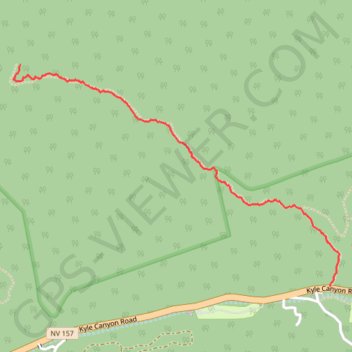
Fletcher Canyon
Hike to Fletcher Canyon from Kyle Canyon Road via the Fletcher Canyon Trail in Mount Charleston Wilderness. #Hiking #Canyon #Mountain #Nature #Forest #Wilderness
- Distance: 2.7 Km
- Elevation gain: 287 m
- Maximum elevation: 2,401 m
- Elevation loss: 18 m
- Minimum elevation: 2,125 m
- Moving time: 44 m 9 s
- Moving speed: 3.7 Km/h
- Maximum speed: 6.9 Km/h
- Total time: 54 m 13 s
- Global speed: 3.0 Km/h
Interactive trail map
Make a donation
Gear up for your next adventure:
As an Amazon Associate, this site earns from qualifying purchases at no extra cost to you.
Trail profile
- Distance: 2.7 Km
- Elevation gain: 287 m
- Maximum elevation: 2,401 m
- Elevation loss: 18 m
- Minimum elevation: 2,125 m
- Moving time: 44 m 9 s
- Moving speed: 3.7 Km/h
- Maximum speed: 6.9 Km/h
- Total time: 54 m 13 s
- Global speed: 3.0 Km/h
Make a donation
Gear up for your next adventure:
As an Amazon Associate, this site earns from qualifying purchases at no extra cost to you.
About this trail
Name: Fletcher Canyon trail, distance, elevation, map, profile, GPS track
Start: Kyle Canyon Road, Mount Charleston, Clark County, Nevada, United States (36.26349 -115.61175)
End: Fletcher Canyon Trail, Mount Charleston, Clark County, Nevada, United States (36.27449 -115.63084)
Coordinates: 36.26349 -115.63129 36.27449 -115.61119
Make a donation
Gear up for your next adventure:
As an Amazon Associate, this site earns from qualifying purchases at no extra cost to you.