Make a donation
Gear up for your next adventure:
As an Amazon Associate, this site earns from qualifying purchases at no extra cost to you.
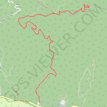
Bertha Peak
Hike from Big Bear Lake to Bertha Peak via Cougar Crest Trail, Pacific Crest National Scenic Trail (PCT) and Bertha Peak Road in the San Bernardino National Forest. #Hiking #Nature #Lake #Mountain #Forest #PCT
- Distance: 5.7 Km
- Elevation gain: 437 m
- Maximum elevation: 2,487 m
- Elevation loss: 41 m
- Minimum elevation: 2,088 m
Interactive trail map
Make a donation
Gear up for your next adventure:
As an Amazon Associate, this site earns from qualifying purchases at no extra cost to you.
Trail profile
- Distance: 5.7 Km
- Elevation gain: 437 m
- Maximum elevation: 2,487 m
- Elevation loss: 41 m
- Minimum elevation: 2,088 m
Make a donation
Gear up for your next adventure:
As an Amazon Associate, this site earns from qualifying purchases at no extra cost to you.
About this trail
Name: Bertha Peak trail, distance, elevation, map, profile, GPS track
End: Bertha Peak Road, San Bernardino County, California, 92333, United States (34.28310 -116.89940)
Coordinates: 34.26393 -116.91587 34.28324 -116.89904
Make a donation
Gear up for your next adventure:
As an Amazon Associate, this site earns from qualifying purchases at no extra cost to you.