
Tuolumne Grove Loop
Loop hike to Tuolumne Grove via Old Big Oak Road, Tunnel Tree and Viewpoint for Giant Sequoias in the Yosemite National Park. #Hiking #Loop #Forest #Park #Nature #Yosemite
- Distance: 4.5 Km
- Elevation gain: 188 m
- Maximum elevation: 1,894 m
- Elevation loss: 188 m
- Minimum elevation: 1,736 m
- Moving time: 1 h 40 m
- Moving speed: 2.7 Km/h
- Maximum speed: 6.6 Km/h
- Total time: 1 h 46 m
- Global speed: 2.5 Km/h
Interactive trail map
Trail profile
- Distance: 4.5 Km
- Elevation gain: 188 m
- Maximum elevation: 1,894 m
- Elevation loss: 188 m
- Minimum elevation: 1,736 m
- Moving time: 1 h 40 m
- Moving speed: 2.7 Km/h
- Maximum speed: 6.6 Km/h
- Total time: 1 h 46 m
- Global speed: 2.5 Km/h
About this trail
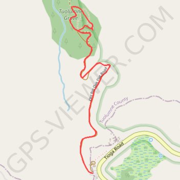
Name: Tuolumne Grove Loop trail, distance, elevation, map, profile, GPS track
Start: Tioga Road, Mariposa County, California, United States (37.75824 -119.80552)
End: Tioga Road, Mariposa County, California, United States (37.75824 -119.80552)
Coordinates: 37.75824 -119.80763 37.77048 -119.80391