Import a GPX file

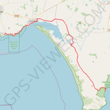
Cape Paterson - Cape Liptrap Coastal Park

#Bike #Liptrap

  • Distance: 57.8 Km
  • Elevation gain: 525 m
  • Maximum elevation: 173 m
  • Elevation loss: 538 m
  • Minimum elevation: 2 m

Interactive trail map

Trail profile

  • Distance: 57.8 Km
  • Elevation gain: 525 m
  • Maximum elevation: 173 m
  • Elevation loss: 538 m
  • Minimum elevation: 2 m

About this trail

Other hiking, mountain biking, running and outdoor activity trails

Click on a trail to view its statistics, map and profile.

Cape Liptrap Coastal Park - Wilsons Promontory National Park

Australia > Victoria > Walkerville

#Bike #Liptrap #Wilsons

Distance: 72.2 Km • Elevation gain: 1,026 m • Maximum elevation: 205 m

Philip Island - Cape Paterson

Australia > Victoria > Cowes

#Bike #Philip

Distance: 65.7 Km • Elevation gain: 522 m • Maximum elevation: 80 m

Gear up for your next adventure:

🛠️Outdoor Repair Kits - Gear repair kits
🔦LED Torches - LED torches for outdoor use
👕UPF 50+ Sun Shirts - Essential protection against the harsh Australian sun during field work
🪫Rechargeable Headlamps - USB rechargeable headlamps
📱Tablet Tripod Mounts - Steady platforms for viewing digital maps or taking long exposures

As an Amazon Associate, this site earns from qualifying purchases at no extra cost to you.