Make a donation
Gear up for your next adventure:
As an Amazon Associate, this site earns from qualifying purchases at no extra cost to you.
Edward Corbould Reserve and Retreat Nature Refuge
- Distance: 33.5 Km
- Elevation gain: 699 m
- Maximum elevation: 137 m
- Elevation loss: 699 m
- Minimum elevation: 14 m
Interactive trail map
Make a donation
Gear up for your next adventure:
As an Amazon Associate, this site earns from qualifying purchases at no extra cost to you.
Trail profile
- Distance: 33.5 Km
- Elevation gain: 699 m
- Maximum elevation: 137 m
- Elevation loss: 699 m
- Minimum elevation: 14 m
Make a donation
Gear up for your next adventure:
As an Amazon Associate, this site earns from qualifying purchases at no extra cost to you.
About this trail
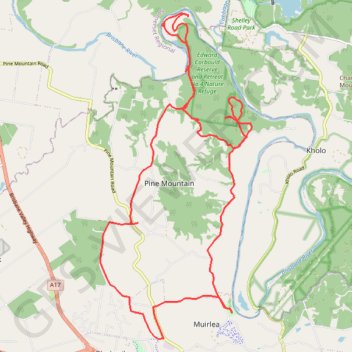
Name: Edward Corbould Reserve and Retreat Nature Refuge trail, distance, elevation, map, profile, GPS track
Start: Coal Creek Walk, Muirlea, Greater Brisbane, Queensland, Australia (-27.56520 152.73921)
End: Riverside Drive, Muirlea, Greater Brisbane, Queensland, Australia (-27.56516 152.73937)
Coordinates: -27.57278 152.70292 -27.49134 152.74566
Topography: Queensland topographic map, elevation, terrain
Make a donation
Gear up for your next adventure:
As an Amazon Associate, this site earns from qualifying purchases at no extra cost to you.
Other hiking, mountain biking, running and outdoor activity trails
Click on a trail to view its statistics, map and profile.