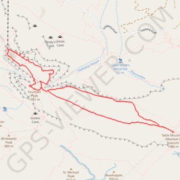
Fountain Peak - Table Mountain
Interactive trail map
Trail profile
- Distance: 6.0 Km
- Elevation gain: 242 m
- Maximum elevation: 1,081 m
- Elevation loss: 237 m
- Minimum elevation: 1,025 m
About this trail
Name: Fountain Peak - Table Mountain trail, distance, elevation, map, profile, GPS track
Coordinates: -33.96686 18.40284 -33.95739 18.42559
Other hiking, mountain biking, running and outdoor activity trails
Click on a trail to view its statistics, map and profile.
Table Mountain traverse from Kloof Corner to Suikerbossie via Maclear's Beacon
South Africa > Western Cape > City of Cape Town > Cape Town
Distance: 20.8 Km • Elevation gain: 1,511 m • Maximum elevation: 1,077 m
Simon's Town - Cape Town
South Africa > Western Cape > City of Cape Town > Simon's Town
#Bike
Distance: 53.9 Km • Elevation gain: 1,127 m • Maximum elevation: 184 m
Route von Longmarket Street nach/zu Rhodesrylaan
South Africa > Western Cape > City of Cape Town > Cape Town
Distance: 12.3 Km • Elevation gain: 149 m • Maximum elevation: 114 m