Thank you for supporting this site ❤️
Make a donation
Make a donation
Gear up for your next adventure:
As an Amazon Associate, this site earns from qualifying purchases at no extra cost to you.
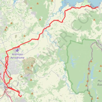
Drury - Kawakawa Bay
Interactive trail map
Thank you for supporting this site ❤️
Make a donation
Make a donation
Gear up for your next adventure:
As an Amazon Associate, this site earns from qualifying purchases at no extra cost to you.
Trail profile
- Distance: 82.0 Km
- Elevation gain: 529 m
- Maximum elevation: 120 m
- Elevation loss: 516 m
- Minimum elevation: 0 m
Thank you for supporting this site ❤️
Make a donation
Make a donation
Gear up for your next adventure:
As an Amazon Associate, this site earns from qualifying purchases at no extra cost to you.
About this trail
Name: Drury - Kawakawa Bay trail, distance, elevation, map, profile, GPS track
Start: 190, MacWhinney Drive, Drury, Franklin, Auckland, 2577, New Zealand (-37.11870 174.98409)
End: 240, MacWhinney Drive, Drury, Franklin, Auckland, 2577, New Zealand (-37.11780 174.98484)
Coordinates: -37.12067 174.94202 -36.94467 175.16926
Thank you for supporting this site ❤️
Make a donation
Make a donation
Gear up for your next adventure:
As an Amazon Associate, this site earns from qualifying purchases at no extra cost to you.
Other hiking, mountain biking, running and outdoor activity trails
Click on a trail to view its statistics, map and profile.