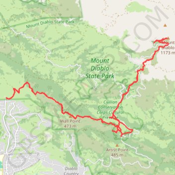
Mount Diablo
Hike from Macedo Ranch Staging Area to Mount Diablo via Wall Pt. Road, Staircase Trail, Summit Trail and Sentinel Rock in the Mount Diablo State Park. #Hiking #Mountain #Nature #Forest #Park
- Distance: 24.7 Km
- Elevation gain: 1,303 m
- Maximum elevation: 1,152 m
- Elevation loss: 1,303 m
- Minimum elevation: 197 m
- Moving time: 5 h 28 m
- Moving speed: 4.5 Km/h
- Maximum speed: 12.1 Km/h
- Total time: 6 h 30 m
- Global speed: 3.8 Km/h
Interactive trail map
Trail profile
- Distance: 24.7 Km
- Elevation gain: 1,303 m
- Maximum elevation: 1,152 m
- Elevation loss: 1,303 m
- Minimum elevation: 197 m
- Moving time: 5 h 28 m
- Moving speed: 4.5 Km/h
- Maximum speed: 12.1 Km/h
- Total time: 6 h 30 m
- Global speed: 3.8 Km/h
About this trail
Name: Mount Diablo trail, distance, elevation, map, profile, GPS track
Start: Wall Pt. Road, Contra Costa County, California, 94507, United States (37.86258 -121.97862)
Coordinates: 37.85043 -121.97873 37.88164 -121.91396
Other hiking, mountain biking, running and outdoor activity trails
Click on a trail to view its statistics, map and profile.
5 Peaks Loop (Mount Olympia, North Peak, Mount Diablo, Eagle Peak and Twin Peaks)
United States > California > Contra Costa County > Clayton
Loop hike from Clayton via Donner Canyon Road, Cardinet Oaks Road, Mount Olympia Road, Mount Olympia, North Peak Road, North Peak, Prospectors Gap, North Peak Trail, Summit Trail, Mount Diablo, Bald Ridge Trail, Eagle Peak Trail, Eagle Peak, Mitchell Rock Trail, Twin Peaks, Mitchell Rock, Oak Road and Murchio…
Distance: 24.2 Km • Elevation gain: 1,543 m • Maximum elevation: 1,152 m