Make a donation
Gear up for your next adventure:
As an Amazon Associate, this site earns from qualifying purchases at no extra cost to you.
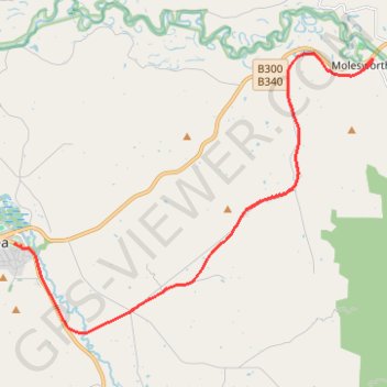
Molesworth - Yea
Great Victorian Rail Trail. #Bike
- Distance: 17.8 Km
- Elevation gain: 189 m
- Maximum elevation: 303 m
- Elevation loss: 192 m
- Minimum elevation: 171 m
Interactive trail map
Make a donation
Gear up for your next adventure:
As an Amazon Associate, this site earns from qualifying purchases at no extra cost to you.
Trail profile
- Distance: 17.8 Km
- Elevation gain: 189 m
- Maximum elevation: 303 m
- Elevation loss: 192 m
- Minimum elevation: 171 m
Make a donation
Gear up for your next adventure:
As an Amazon Associate, this site earns from qualifying purchases at no extra cost to you.
About this trail
Name: Molesworth - Yea trail, distance, elevation, map, profile, GPS track
End: Station Street, Yea, Shire of Murrindindi, Victoria, 3717, Australia (-37.21345 145.42791)
Coordinates: -37.23619 145.42791 -37.16479 145.54285
Topography: Victoria topographic map, elevation, terrain
Make a donation
Gear up for your next adventure:
As an Amazon Associate, this site earns from qualifying purchases at no extra cost to you.
Other hiking, mountain biking, running and outdoor activity trails
Click on a trail to view its statistics, map and profile.
Alexandra - Cathkin - Molesworth
Australia > Victoria > Alexandra
#Bike
Distance: 19.7 Km • Elevation gain: 197 m • Maximum elevation: 288 m
Tallarook - Eildon - Hurstbridge
Australia > Victoria > Tallarook
#Bike
Distance: 278.8 Km • Elevation gain: 4,897 m • Maximum elevation: 868 m
Yea - Granite
Great Victorian Rail Trail. #Bike
Distance: 24.6 Km • Elevation gain: 257 m • Maximum elevation: 220 m