Cathedral Lake and Floating Island Lake
Hike to Cathedral Lake and Floating Island Lake via Mount Tallac Trail above the Fallen Leaf Lake in the Desolation Wilderness. #Hiking #Nature #Lake #Mountain #Forest #Wilderness
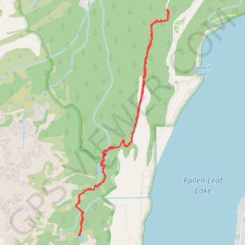
- Distance: 8.8 Km
- Elevation gain: 368 m
- Maximum elevation: 2,328 m
- Elevation loss: 368 m
- Minimum elevation: 1,964 m
- Moving time: 3 h 50 m
- Moving speed: 2.3 Km/h
- Maximum speed: 4.7 Km/h
- Total time: 5 h 9 m
- Global speed: 1.7 Km/h
Interactive trail map
Trail profile
- Distance: 8.8 Km
- Elevation gain: 368 m
- Maximum elevation: 2,328 m
- Elevation loss: 368 m
- Minimum elevation: 1,964 m
- Moving time: 3 h 50 m
- Moving speed: 2.3 Km/h
- Maximum speed: 4.7 Km/h
- Total time: 5 h 9 m
- Global speed: 1.7 Km/h
About this trail
Name: Cathedral Lake and Floating Island Lake trail, distance, elevation, map, profile, GPS track
Coordinates: 38.89418 -120.08260 38.92190 -120.06801
Other hiking, mountain biking, running and outdoor activity trails
Click on a trail to view its statistics, map and profile.
Mount Tallac via Floating Island / Mount Tallac Trail in Lake Tahoe Basin Management Unit
United States > California > El Dorado County
The Mount Tallac Trail offers a breathtaking and demanding route with a rewarding summit experience. Early sections of the hike pass by serene alpine lakes like Floating Island Lake, offering a peaceful atmosphere and views of the surrounding mountains, including Fallen Leaf Lake. As you ascend, the trail…
Distance: 7.3 Km • Elevation gain: 977 m • Maximum elevation: 2,958 m
Mount Tallac Trail in Desolation Wilderness
United States > California > El Dorado County
The Mount Tallac Trail in Desolation Wilderness offers hikers breathtaking vistas of Fallen Leaf Lake and Lake Tahoe, with the Floating Island Lake and Cathedral Lake gracing the path. As the ascent continues, the trail meanders through alpine meadows adorned with wildflowers, leading to rugged granite ridges.…
Distance: 15.8 Km • Elevation gain: 994 m • Maximum elevation: 2,960 m
Desolation Wilderness 7 Summits Loop Hike
United States > California > El Dorado County
Ralston Peak, Pyramid Peak, Mount Agassiz, Mount Price, Jacks Peak, Dicks Peak and Mount Tallac.
Distance: 38.6 Km • Elevation gain: 2,956 m • Maximum elevation: 3,034 m