Make a donation
Gear up for your next adventure:
As an Amazon Associate, this site earns from qualifying purchases at no extra cost to you.
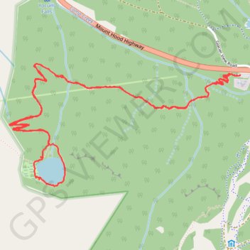
Mirror Lake Loop Trail in Mount Hood National Forest
The Mirror Lake Loop Trail offers a moderately challenging yet scenic hike that begins in a conifer forest and steadily ascends to the serene Mirror Lake. Along the loop around the lake, you'll be treated to occasional views of the majestic Mount Hood reflected in the water, especially from the west side, where the trail passes through a marshy area with wooden boardwalks. The surrounding forest, dotted with wild rhododendrons and mountain huckleberries, adds a lush and peaceful atmosphere to the experience. #Hiking #Mountain #Lake #Forest #Nature
- Distance: 7.0 Km
- Elevation gain: 255 m
- Maximum elevation: 1,272 m
- Elevation loss: 256 m
- Minimum elevation: 1,100 m
- Moving time: 1 h 38 m
- Moving speed: 4.3 Km/h
- Maximum speed: 12.5 Km/h
- Total time: 1 h 44 m
- Global speed: 4.0 Km/h
Interactive trail map
Make a donation
Gear up for your next adventure:
As an Amazon Associate, this site earns from qualifying purchases at no extra cost to you.
Trail profile
- Distance: 7.0 Km
- Elevation gain: 255 m
- Maximum elevation: 1,272 m
- Elevation loss: 256 m
- Minimum elevation: 1,100 m
- Moving time: 1 h 38 m
- Moving speed: 4.3 Km/h
- Maximum speed: 12.5 Km/h
- Total time: 1 h 44 m
- Global speed: 4.0 Km/h
Make a donation
Gear up for your next adventure:
As an Amazon Associate, this site earns from qualifying purchases at no extra cost to you.
About this trail
Name: Mirror Lake Loop Trail in Mount Hood National Forest trail, distance, elevation, map, profile, GPS track
Coordinates: 45.29614 -121.79625 45.30329 -121.77704
Make a donation
Gear up for your next adventure:
As an Amazon Associate, this site earns from qualifying purchases at no extra cost to you.
Other hiking, mountain biking, running and outdoor activity trails
Click on a trail to view its statistics, map and profile.
Tom, Dick and Harry Mountain via Mirror Lake Trail in Mount Hood National Forest
United States > Oregon > Clackamas County
The hike to Tom, Dick, and Harry Mountain via the Mirror Lake Trail offers a rewarding experience with diverse natural beauty. Starting at the Mirror Lake Trailhead, the path meanders through lush forests, leading to the Mirror Lake, which reflects the surrounding landscape. Continuing beyond the lake, the…
Distance: 13.2 Km • Elevation gain: 547 m • Maximum elevation: 1,521 m
Northern part of the Pacific Crest Trail (PCT)
United States > Oregon > Klamath County
Hike on the Pacific Crest National Scenic Trail from Crater Lake to Canada Border through Oregon and Washington along the Sierra Nevada and Cascade mountain ranges. #Hiking #Mountain #SierraNevada #Cascade #Nature #Forest #Park #PCT
Distance: 1,198.3 Km • Elevation gain: 44,308 m • Maximum elevation: 2,307 m
Make a donation
Gear up for your next adventure:
As an Amazon Associate, this site earns from qualifying purchases at no extra cost to you.