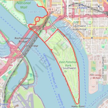
Tidal Basin, Jefferson Memorial, Hains Point and East Potomac Park Loop
This loop hike offers a serene escape enriched with picturesque views of cherry blossom trees, expansive vistas of the Potomac River, and significant landmarks like the Thomas Jefferson Memorial. This route is especially vibrant during the cherry blossom season and is ideal for leisurely strolls, making it a delightful option for both nature lovers and those interested in the historical and cultural elements of Washington, D.C. #Hiking #Loop #River #Nature
- Distance: 9.6 Km
- Elevation gain: 35 m
- Maximum elevation: 6 m
- Elevation loss: 35 m
- Minimum elevation: -1 m
- Moving time: 1 h 57 m
- Moving speed: 4.9 Km/h
- Maximum speed: 22.0 Km/h
- Total time: 1 h 58 m
- Global speed: 4.8 Km/h
Interactive trail map
Trail profile
- Distance: 9.6 Km
- Elevation gain: 35 m
- Maximum elevation: 6 m
- Elevation loss: 35 m
- Minimum elevation: -1 m
- Moving time: 1 h 57 m
- Moving speed: 4.9 Km/h
- Maximum speed: 22.0 Km/h
- Total time: 1 h 58 m
- Global speed: 4.8 Km/h
About this trail
Name: Tidal Basin, Jefferson Memorial, Hains Point and East Potomac Park Loop trail, distance, elevation, map, profile, GPS track
Coordinates: 38.85833 -77.03976 38.88567 -77.02185
Other hiking, mountain biking, running and outdoor activity trails
Click on a trail to view its statistics, map and profile.
Washington DC's Monuments and Memorials Loop Walk
This loop walk offers a serene and reflective experience. Starting at the White House, you pass through the National Mall, observing landmarks such as the Washington Monument, World War II Memorial, and the Lincoln Memorial before circling the Tidal Basin to see memorials honoring Jefferson, Roosevelt, and…
Distance: 18.5 Km • Elevation gain: 191 m • Maximum elevation: 48 m
Washington DC
Distance: 9.8 Km • Elevation gain: 129 m • Maximum elevation: 40 m