Make a donation
Gear up for your next adventure:
As an Amazon Associate, this site earns from qualifying purchases at no extra cost to you.
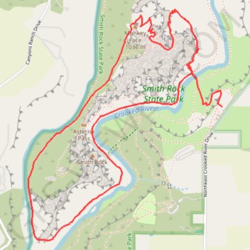
Monkey Face Loop via Misery Ridge Trail and River Trail in Smith Rock State Park
The Monkey Face Loop offers a remarkable adventure through Smith Rock State Park, showcasing sweeping panoramas of towering rock formations and the winding Crooked River. Hikers are treated to dramatic views from the summit of Misery Ridge, where the valley below unfolds in all its rugged beauty, with the iconic Monkey Face rock formation standing as a landmark in the distance. As the route descends, it traces the river's edge, offering a serene contrast to the arid heights, making this trail a visually diverse and rewarding experience. #Hiking #Mountain #Nature #Loop #River #Rock
- Distance: 7.7 Km
- Elevation gain: 561 m
- Maximum elevation: 1,007 m
- Elevation loss: 547 m
- Minimum elevation: 806 m
Interactive trail map
Make a donation
Gear up for your next adventure:
As an Amazon Associate, this site earns from qualifying purchases at no extra cost to you.
Trail profile
- Distance: 7.7 Km
- Elevation gain: 561 m
- Maximum elevation: 1,007 m
- Elevation loss: 547 m
- Minimum elevation: 806 m
Make a donation
Gear up for your next adventure:
As an Amazon Associate, this site earns from qualifying purchases at no extra cost to you.
About this trail
Name: Monkey Face Loop via Misery Ridge Trail and River Trail in Smith Rock State Park trail, distance, elevation, map, profile, GPS track
Start: Rim Rock Trail, Deschutes County, Oregon, 97760, United States (44.36713 -121.13738)
End: Northeast Crooked River Drive, Deschutes County, Oregon, 97760, United States (44.36633 -121.13713)
Coordinates: 44.35931 -121.15130 44.37143 -121.13713
Make a donation
Gear up for your next adventure:
As an Amazon Associate, this site earns from qualifying purchases at no extra cost to you.
Other hiking, mountain biking, running and outdoor activity trails
Click on a trail to view its statistics, map and profile.
Misery Ridge Trail and River Trail Loop in Smith Rock State Park
United States > Oregon > Deschutes County
The Misery Ridge Trail and River Trail Loop offers a challenging yet rewarding hike. The trail takes you through switchbacks leading to panoramic views of the high desert landscape, including the iconic Monkey Face rock formation and sweeping vistas of the Crooked River as it winds through the canyon. Once you…
Distance: 5.8 Km • Elevation gain: 331 m • Maximum elevation: 1,007 m
Northern part of the Pacific Crest Trail (PCT)
United States > Oregon > Klamath County
Hike on the Pacific Crest National Scenic Trail from Crater Lake to Canada Border through Oregon and Washington along the Sierra Nevada and Cascade mountain ranges. #Hiking #Mountain #SierraNevada #Cascade #Nature #Forest #Park #PCT
Distance: 1,198.3 Km • Elevation gain: 44,308 m • Maximum elevation: 2,307 m