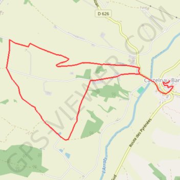
2013-08-07T15:57:23Z
- Distance: 7.9 Km
- Elevation gain: 169 m
- Maximum elevation: 268 m
- Elevation loss: 225 m
- Minimum elevation: 168 m
Interactive trail map
Trail profile
- Distance: 7.9 Km
- Elevation gain: 169 m
- Maximum elevation: 268 m
- Elevation loss: 225 m
- Minimum elevation: 168 m
About this trail
Name: 2013-08-07T15:57:23Z trail, distance, elevation, map, profile, GPS track
Coordinates: 43.56701 0.69091 43.58186 0.72498
Other hiking, mountain biking, running and outdoor activity trails
Click on a trail to view its statistics, map and profile.
Southern section — European Divide Trail
France > Auvergne-Rhône-Alpes > Drôme > Valence
Distance: 2,423.8 Km • Elevation gain: 42,375 m • Maximum elevation: 2,005 m
1 LUCENA - MONTPELLIER
Distance: 2,964.4 Km • Elevation gain: 29,500 m • Maximum elevation: 1,048 m
Chemin de Saint-Jacques-de-Compostelle
Switzerland > Geneva > Geneva
Distance: 1,117.8 Km • Elevation gain: 25,262 m • Maximum elevation: 1,430 m