Make a donation
Gear up for your next adventure:
As an Amazon Associate, this site earns from qualifying purchases at no extra cost to you.
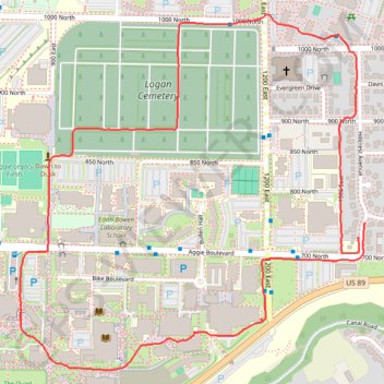
Logan Loop Walk
- Distance: 3.7 Km
- Elevation gain: 24 m
- Maximum elevation: 1,467 m
- Elevation loss: 24 m
- Minimum elevation: 1,456 m
- Moving time: 41 m 32 s
- Moving speed: 5.4 Km/h
- Maximum speed: 7.4 Km/h
- Total time: 41 m 32 s
- Global speed: 5.4 Km/h
Interactive trail map
Make a donation
Gear up for your next adventure:
As an Amazon Associate, this site earns from qualifying purchases at no extra cost to you.
Trail profile
- Distance: 3.7 Km
- Elevation gain: 24 m
- Maximum elevation: 1,467 m
- Elevation loss: 24 m
- Minimum elevation: 1,456 m
- Moving time: 41 m 32 s
- Moving speed: 5.4 Km/h
- Maximum speed: 7.4 Km/h
- Total time: 41 m 32 s
- Global speed: 5.4 Km/h
Make a donation
Gear up for your next adventure:
As an Amazon Associate, this site earns from qualifying purchases at no extra cost to you.
About this trail
Name: Logan Loop Walk trail, distance, elevation, map, profile, GPS track
Coordinates: 41.74149 -111.81241 41.75016 -111.80113
Make a donation
Gear up for your next adventure:
As an Amazon Associate, this site earns from qualifying purchases at no extra cost to you.
Other hiking, mountain biking, running and outdoor activity trails
Click on a trail to view its statistics, map and profile.
Bonneville Shoreline Trail
United States > Utah > Cache County > Logan
cycling, mtb
Distance: 9.3 Km • Elevation gain: 199 m • Maximum elevation: 1,554 m
2025-05-21_08-53_Wed
United States > Utah > Cache County > Logan
Canal Road and Canyon Road Loop Walk
Distance: 4.5 Km • Elevation gain: 78 m • Maximum elevation: 1,468 m